Discover Ontario's history as told through its plaques
2004 - Now in our 15th Year - 2019
To find out all about me, you can visit the Home Page
Looking at this page on a smartphone?
For best viewing, hold your phone
in Landscape mode (Horizontal)
The Wilkins Expedition 1763
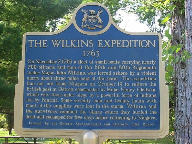
Photo by Alan L Brown - Posted August, 2004
Photo from Google Street View ©2014 Google - Posted January, 2014
Plaque Location
The Municipality of Chatham-Kent
In Rondeau Provincial Park (admission fee in season)
at the corner of Lakeshore Road and Rondeau Park Road
Coordinates: N 42 16.894 W 81 50.598 |
Plaque Text
On November 7, 1763 a fleet of small boats carrying nearly 700 officers and men of the 60th and 80th Regiments under Major John Wilkins, was forced ashore by a violent storm about 5 km east of this point. The expedition had set out from Niagara on October 19 to relieve the British post at Detroit, commanded by Major Henry Gladwin, which was then under siege by a powerful force of Indians led by Pontiac. Some seventy men and twenty boats with most of the supplies were lost in the storm. Wilkins and the survivors reached the shore where they buried the dead and encamped for five days before returning to Niagara.
More
Disasters
Here are the visitors' comments for this page.
(none yet)
Here's where you can send me a comment for this page.
Note: Your email address will be posted at the end of your comment so others can respond to you unless you request otherwise.
Note: Comments are moderated. Yours will appear on this page within 24 hours (usually much sooner).
Note: As soon as I have posted your comment, a reply to your email will be sent informing you.
To send me your comment, click .
Thanks
Alan L Brown
Webmaster
Note: If you wish to send me a personal email, click .