Discover Ontario's history as told through its plaques
2004 - Now in our 15th Year - 2019
To find out all about me, you can visit the Home Page
Looking at this page on a smartphone?
For best viewing, hold your phone
in Landscape mode (Horizontal)
The Founding of Pickering
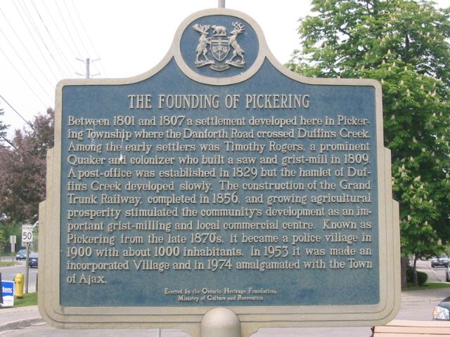
Photo by Alan L Brown - Posted June, 2004
Photo from Google Street View ©2011 Google - Posted January, 2011
Plaque Location
The Region of Durham
The Town of Ajax
In a small park at the junction of
Kingston Road West (Road 2) and Old Kingston Road
just west of Church Street
Coordinates: N 43 51.262 W 79 03.416 |
Plaque Text
Between 1801 and 1807 a settlement developed here in Pickering Township where the Danforth Road crossed Duffin's Creek. Among the early settlers was Timothy Rogers, a prominent Quaker and colonizer who built a saw and grist-mill in 1809. A post-office was established in 1829 but the hamlet of Duffin's Creek developed slowly. The construction of the Grand Trunk Railway, completed in 1856, and growing agricultural prosperity stimulated the community's development as an important grist-milling and local commercial centre. Known as Pickering from the late 1870's, it became a police village in 1900 with about 1000 inhabitants. In 1953 it was made an incorporated Village and in 1974 amalgamated with the Town of Ajax.
More
Information
More
Settlements
More
Ajax Plaques
Here are the visitors' comments for this page.
(none yet)
Here's where you can send me a comment for this page.
Note: Your email address will be posted at the end of your comment so others can respond to you unless you request otherwise.
Note: Comments are moderated. Yours will appear on this page within 24 hours (usually much sooner).
Note: As soon as I have posted your comment, a reply to your email will be sent informing you.
To send me your comment, click .
Thanks
Alan L Brown
Webmaster
Note: If you wish to send me a personal email, click .