Discover Ontario's history as told through its plaques
2004 - Now in our 15th Year - 2019
To find out all about me, you can visit the Home Page
Looking at this page on a smartphone?
For best viewing, hold your phone
in Landscape mode (Horizontal)
Acton
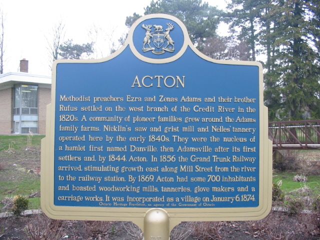
Photo by Alan L Brown - Posted December, 2010

Photo by contributor Wayne Adam - Posted November, 2011
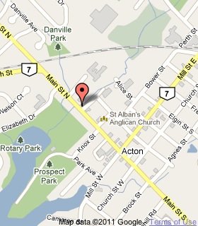
Plaque Location
The Region of Halton
The Town of Halton Hills
In Acton, in front of the Halton Hills Public Library
on the northeast corner of
Main Street North (Highway 7) and River Street
Coordinates: N 43 37.899 W 80 02.632 |
 |
Plaque Text
Methodist preachers Ezra and Zenas Adams and their brother Rufus settled on the west branch of the Credit River in the 1820s. A community of pioneer families grew around the Adams family farms. Nicklin's saw and grist mill and Nelles' tannery operated here by the early 1840s. They were the nucleus of a hamlet first named Danville, then Adamsville after its first settlers and, by 1844, Acton. In 1856 the Grand Trunk Railway arrived, stimulating growth east along Mill Street from the river to the railway station. By 1869, Acton had some 700 inhabitants and boasted woodworking mills, tanneries, glove makers and a carriage works. It was incorporated as a village on January 6, 1874.
More
Information
More
Settlements
Here are the visitors' comments for this page.
(none yet)
Here's where you can send me a comment for this page.
Note: Your email address will be posted at the end of your comment so others can respond to you unless you request otherwise.
Note: Comments are moderated. Yours will appear on this page within 24 hours (usually much sooner).
Note: As soon as I have posted your comment, a reply to your email will be sent informing you.
To send me your comment, click .
Thanks
Alan L Brown
Webmaster
Note: If you wish to send me a personal email, click .