Discover Ontario's history as told through its plaques
2004 - Now in our 12th Year - 2016
To see what's new on this site, you can visit the Home Page
Looking at this page on a smartphone?
For best viewing, hold your phone
in Landscape mode (Horizontal)
Gananoque
Photos by Alan L Brown - Posted July, 2009

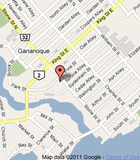
Plaque Location
The United Counties of Leeds & Grenville
The Town of Gananoque
On a pylon on the west side of Stone Street
just south of Pine Street south of King Street
Coordinates: N 44 19.719 W 76 09.701 |
 |
Plaque Text
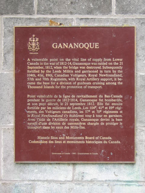
A vulnerable point on the vital line of supply from Lower Canada in the war of 1812-14, Gananoque was raided on the 21 September, 1812, when the bridge was destroyed. Subsequently fortified by the Leeds Militia and garrisoned in turn by the 104th, 41st, 89th, Canadian Voltigeurs, Royal Newfoundland, 57th and 70th Regiments, with Royal Artillery support, it became the base for a division of gunboats cruising among the Thousand Islands for the protection of transport.
Related Ontario plaque
Raid on Gananoque 1812
More
War of 1812
Here are the visitors' comments for this page.
(none yet)
Here's where you can sent me a comment for this page.
Note: Your email address will be posted at the end of your comment so others can respond to you unless you request otherwise.
Note: Comments are moderated. Yours will appear on this page within 24 hours (usually much sooner).
Note: As soon as I have posted your comment, a reply to your email will be sent informing you.
To send me your comment, click .
Thanks
Alan L Brown
Webmaster
Note: If you wish to send me a personal email, click .