Discover Ontario's history as told through its plaques
2004 - Now in our 11th Year - 2015
To see what's new on this site, you can visit the Home Page
Looking at this page on a smartphone?
For best viewing, hold your phone
in Landscape mode (Horizontal)
Founding of Port Colborne
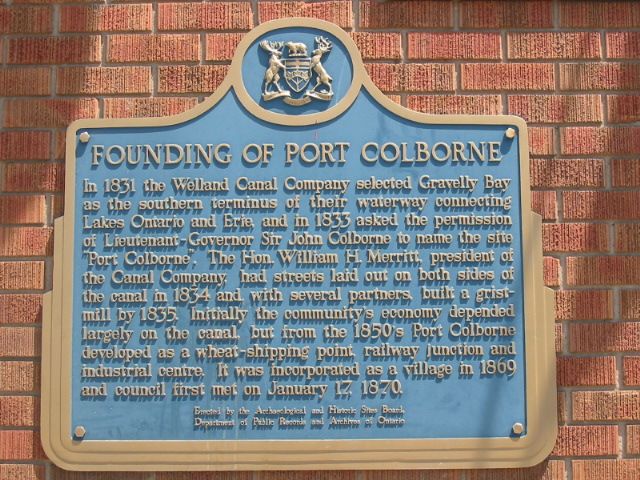
Photo by Alan L Brown - Posted August, 2004
Photo from Google Street View ©2010 Google - Posted December, 2010
Plaque Location
The Region of Niagara
The City of Port Colborne
On the northeast corner of
King Street and Clarence Street West
Coordinates: N 42 53.186 W 79 15.077 |
Plaque Text
In 1831 the Welland Canal Company selected Gravelly Bay as the southern terminus of their waterway connecting Lakes Ontario and Erie, and in 1833 asked the permission of Lieutenant-Governor Sir John Colborne to name the site "Port Colborne". The Hon. William H. Merritt, president of the Canal Company, had streets laid out on both sides of the canal in 1834 and, with several partners, built a grist-mill by 1835. Initially the community's economy depended largely on the canal, but from the 1850's Port Colborne developed as a wheat-shipping point, railway junction and industrial centre. In was incorporated as a village in 1869 and council first met on January 17, 1870.
Related Ontario plaques
The First Welland Canal 1824-1833
William Hamilton Merritt 1793-1862
More
Information
More
Settlements
Here are the visitors' comments for this page.
(none yet)
Here's where you can sent me a comment for this page.
Note: If your comment includes a question, it's best to include your email address in your comment so others can respond to you.
Note: Comments are moderated. Yours will appear on this page within 24 hours (usually much sooner).
Note: As soon as I have posted your comment, a reply to your email will be sent informing you.
To send me your comment, click .
Thanks
Alan L Brown
Webmaster
Note: If you wish to send me a personal email, click .