Discover Ontario's history as told through its plaques
2004 - Now in our 11th Year - 2015
To see what's new on this site, you can visit the Home Page
Looking at this page on a smartphone?
For best viewing, hold your phone
in Landscape mode (Horizontal)
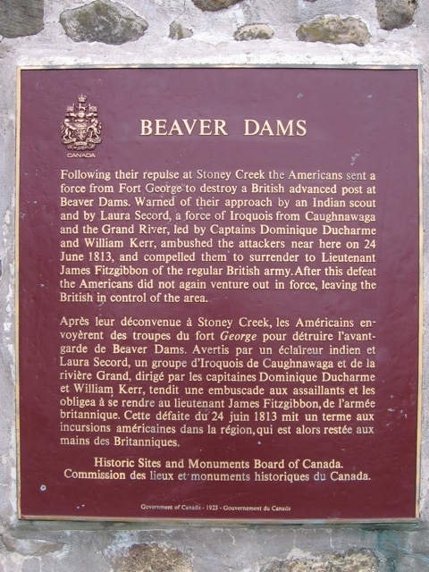
Beaver Dams
Photos by contributor Wayne Adam - Posted June, 2009
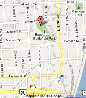
Plaque Location
The Region of Niagara
The City of Thorold
In Beaverdams Battlefield Park, about three quarters
of the way between the parking lot on Ormond Street South
across from Portland Street and the
Sullivan Avenue pedestrian entrance
Coordinates: N 43 07.356 W 79 12.089 |
 |
Plaque Text
Following their repulse at Stoney Creek the Americans sent a force from Fort George to destroy a British advanced post at Beaver Dams. Warned of their approach by an Indian scout and by Laura Secord, a force of Iroquois from Caughnawaga and the Grand River, led by Captains Dominique Ducharme and William Kerr, ambushed the attackers near here on 24 June 1813, and compelled them to surrender to Lieutenant James Fitzgibbon of the regular British army. After this defeat the Americans did not again venture out in force, leaving the British in control of the area.
Related Ontario plaques
Battle of Stoney Creek
Fort George
Laura Secord (1775-1868)
More
Information
More
War of 1812
More
Thorold Plaques
Here are the visitors' comments for this page.
> Posted June 23, 2015
The Battle of Beaver Dams memorial service will be held this Wednesday, June 24, 2015, to mark the 202nd anniversary of the battle. It begins at 6:30 PM at Battle of Beaver Dams National Historic Site, corner of Davis & Old Thorold Stone Roads, in Thorold. Note: this is not the same location as the federal cairn, pictured, which was moved from the battle site.
-Wayne
> Posted October 21, 2014
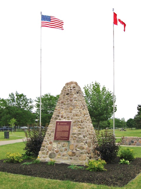
The battlefield was originally marked in 1923 with a federal cairn and plaque, but the cairn was removed to a downtown park in 1976, leaving the battlefield unidentified.The battle's bicentennial in 2013 prompted the Niagara 1812 Legacy Council and the City of Thorold to remark it. Today, three plaques are affixed to a large boulder placed in a now-barren industrial landscape at the southeast corner of Davis Road and Old Thorold Stone Road. Four flagpoles cup the boulder on one side.
Coordinates: 43.117623, -79.185455
Battle of Beaverdams
June 24, 1813
The Historic Sites and Monuments Board of Canada erected a stone cairn on this location in 1923, designating the Battlefield of Beaverdams as a National Historic Site. The cairn was relocated to the Battle of Beaverdams Park in downtown Thorold in 1976.
Battle of Beaverdams
On the morning of June 24, 1813, an invading American force of some 685 men, under the command of Lieutenant-Colonel Charles Boerstler, marched along Mountain Road (parts of which are no longer visible today) that ran through this intersection. They intended to capture the British outpost commanded by Lieutenant James Fitzgibbon, located two miles to the west at the Decew House. As the Americans approached the nearby Beechwoods, they were ambushed by about 400 Native warriors and soundly defeated in a battle that raged for nearly three hours.
Virtually all the fighting on the British side was led by Native warriors, while Fitzgibbon and his superior, Major Peter de Haren, arrived only in time to accept the surrender and claim the victory. The terms of the surrender were signed at the Miller house, located south of this site near Beaverdams Creek. Laura Secord's timely information of an impending American attack, delivered to Fitzgibbon two days earlier, contributed to the victory.
The fighting extended across the fields and in the Beechwoods, an area stretching from today's Niagara Falls/Thorold Municipal Boundary in the east, toward ten mile creek to the north and Beaverdams creek to the south, and to the west, where successive Welland Canal Channels and industrial development have drastically altered the topography of the battlefield.
Native warriors suffered casualties in the Battle of Beaverdams, and they assured British victories in other battles of the War of 1812-1814. They are here recognized with lasting gratitude.
Victory at Beaverdams
"The victory was entirely due to the Indians," wrote Captain Dominique Ducharme of the Indian Department of the victory at Beaverdams, "who were not only deprived of the booty which had been promised them, but of the honour and glory which they had won."
As the Americans advanced toward the British stronghold at Burlington Heights, hoping to crush the British's ability to continue the war, the victory at Stone Creek inspired the Native warriors who assembled at Beaverdams in June 1813. Composed primarily of men from Six Nations on the Grand River and Kahnawake, Tyendinaga, and Kanesatake along the St. Lawrence River, the Native warriors were able to cause the surrender of the American force.
Led by Ahyonwa'ehs (Captain John Brant), his cousin, Captain William Johnson Kerr, and Captain Ducharme, about 400 warriors defeated the 685 Americans. During the heat of the battle, most of the Grand River warriors left the battlefield, unhappy that they had not received promised pay and provisions from previous service. This left their Mohawk cousins from Lower Canada to complete the fighting. Ducharme's warriors were responsible for the great victory; however, they were denied their proper share of the war booty, so they soon left the Niagara peninsula and returned to their homes.
This plaque finally recognizes the essential contribution made by St. Lawrence warriors in the Victory at Beaverdams.
> Posted April 3, 2012
This site represents one of the earliest attempts to create a national historical park. In 1914, a convention of Ontario historical and patriotic groups resolved to ask the Department of the Interior "to develop a 40-acre site near Thorold as a national battlefield park commemorating the Battle of Beaver Dams."(1) The move may have been inspired by the creation, earlier that year, of Fort Howe National Park in New Brunswick--the first site admitted to the national park system on the basis of its historical significance.(2)
There were other galvanizing precedents. While there was no National Park Service in the United States until 1916, battlefields of the Civil War were designated and managed by the War Department: Chickamauga and Chattanooga (created 1890), Antietam (1890), Shiloh (1894), Gettysburg (1895), Vicksburg (1899), and Chalmette (1907).(3) In Quebec, the Plains of Abraham were developed as a landscaped historical park, following creation of the National Battlefields Commission in 1908. Yet none of these sites were administered by a national park service.
Had Beaver Dams been made a national parkland in 1914, it would have been the first battlefield within a national park system in either country. Moreover, if legislation had adopted the convention's recommendation, it would have been the first "National Battlefield Park" in Canada or the United States. (Existing U.S. battlefields had been designated National Military Parks, with one National Battlefield Site.(4))
Alas, Beaver Dams would never join the national park system. Discussion of a national battlefield here, however, along with the ad hoc creation of Fort Anne National Park in 1917, helped highlight the need for a coherent heritage policy, prompting the Interior minister to ask J.B. Harkin of the Parks Branch to develop one. That led to creation of the Historic Sites and Monuments Board in 1919--the genesis of national historic sites and historical parks for years to come. In 1921, soon after its formation, the Board designated the Battle of Beaver Dams a national historic site, one of its earliest selections.
Two years later, in 1923, this cairn was erected, but not where it is today. It was put up on the battlefield, near Davis Road and Old Thorold Stone Road, about 1.4 kilometres southeast of its present location. The original battle site is now unmarked, but remains the designated place of the national historic site, once the focus of those early efforts to create a National Battlefield Park. The cairn and its plaque were removed to their current location at Battle of Beaverdams [sic] Park, which was developed later in the 20th century.
-Wayne
Notes:
(1) Clarence M. Warner, president, Ontario Historical Society, to William J. Roche, Minister of the Interior, July 3, 1914. Cited in C.J. Taylor, Negotiating the Past: The Making of Canada's National Historic Parks and Sites, 1990, p. 30. (The Dominion Parks Branch was under the jurisdiction of the Department of the Interior.)
(2) Canada Gazette, vol. 47, n. 41, April 11, 1914, page 8. Fort Howe in Saint John, NB, was designated a National Park on March 30, 1914. It was returned to the city in 1930, later designated a national historic site outside the national park system.
(3) The National Parks: Shaping the System, U.S. National Park Service, 2005, p. 41. Battlefields would not be administered by the National Park Service until 1933.
(4) Ibid.
Here's where you can sent me a comment for this page.
Note: If your comment includes a question, it's best to include your email address in your comment so others can respond to you.
Note: Comments are moderated. Yours will appear on this page within 24 hours (usually much sooner).
Note: As soon as I have posted your comment, a reply to your email will be sent informing you.
To send me your comment, click .
Thanks
Alan L Brown
Webmaster
Note: If you wish to send me a personal email, click .