Discover Ontario's history as told through its plaques
2004 - Now in our 13th Year - 2017
To see what's new on this site, you can visit the Home Page
Looking at this page on a smartphone?
For best viewing, hold your phone
in Landscape mode (Horizontal)
Magnetawan Lock
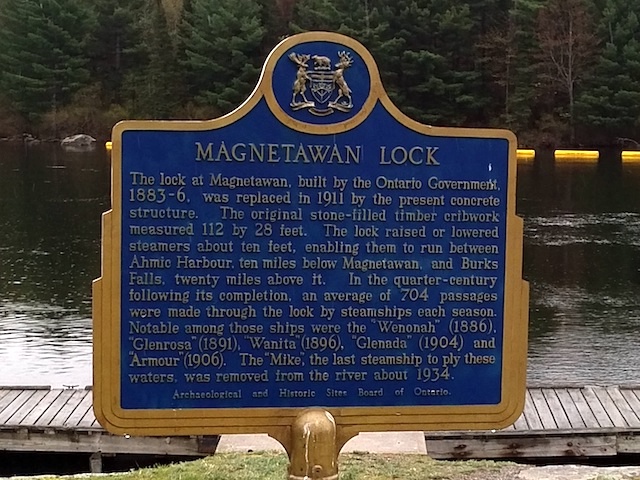
Photo by contributor Brian Bockus - Posted May, 2017
Photo from Google Street View ©2010 Google - Posted November, 2010
Plaque Location
The District of Parry Sound
The Municipality of Magnetawan
On the south side of Highway 520
just east of Bridge Street
Coordinates: N 45 39.948 W 79 38.484 |
Plaque Text
The lock at Magnetawan, built by the Ontario Government, 1883-6, was replaced in 1911 by the present concrete structure. The original stone-filled timber cribwork measured 34 by 8.5 metres. The lock raised or lowered steamers about 3 metres, enabling them to run between Ahmic Harbour, 16 km below Magnetawan, and Burk's Falls, 32 km above it. In the quarter-century following its completion, an average of 704 passages were made through the locks by steamships each season. Notable among these ships were the "Wenonah" (1886), "Glenrosa" (1891), "Wanita" (1896), "Glenada" (1904) and "Armour" (1906). The "Mike", the last steamship to ply these waters, was removed from the river about 1934.
Related Ontario plaque
Magnetawan River Steam Navigation
More
Canals
Here are the visitors' comments for this page.
(none yet)
Here's where you can sent me a comment for this page.
Note: Your email address will be posted at the end of your comment so others can respond to you unless you request otherwise.
Note: Comments are moderated. Yours will appear on this page within 24 hours (usually much sooner).
Note: As soon as I have posted your comment, a reply to your email will be sent informing you.
To send me your comment, click .
Thanks
Alan L Brown
Webmaster
Note: If you wish to send me a personal email, click .