Discover Ontario's history as told through its plaques
2004 - Now in our 15th Year - 2019
To find out all about me, you can visit the Home Page
Looking at this page on a smartphone?
For best viewing, hold your phone
in Landscape mode (Horizontal)
Penetanguishene Road 1814

Photo by Alan L Brown - Posted May, 2005
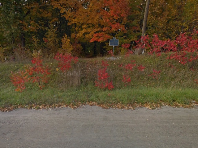
Photo from Google Street View ©2016 Google - Posted November, 2016
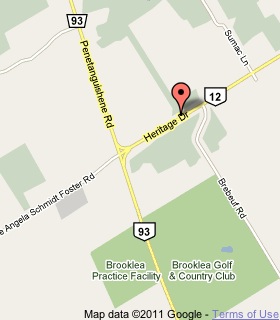
Plaque Location
The County of Simcoe
The Town of Midland
On the north side of Heritage Drive (Highway 12)
.5 km east of Highway 93
Coordinates: N 44 43.267 W 79 53.553 |
 |
Plaque Text
The course of this road from Kempenfeldt Bay to the site of Penetanguishene was first surveyed by Samuel Wilmot in 1811. Dr. William (Tiger) Dunlop supervised its construction in the fall of 1814 and, although frequently impassible for heavy loads, it served for many years as a supply route to the garrison at Penetanguishene. Under a system of free grants, most of the land immediately adjacent to the road was settled 1819-1830.
Related Ontario plaques
Penetanguishene
"Tiger" Dunlop 1792-1848
More
Information
More
Roads
More
Midland Plaques
Here are the visitors' comments for this page.
> Posted December 3, 2012
The sign is located to the north side of Highway 12 just east of Highway 93 (as shown in the photos and on the map). There is a high volume of traffic travelling at high speeds along Highway 12 in this section. There is not much of a road shoulder as well as a deep ditch in front of the historical plaque. It is hard to park and the driver must open their car door into the lane of traffic with reduced visibility as the location is just over the crest of a hill. It is difficult to read the sign when standing on the road side of the ditch and if you decide to cross over the ditch there is not much room to stand in front of the plaque without stepping into the ditch. For these reasons, the current location is less than ideal. The directional signs on Highway 93 (now County Road 93) in Midland (just north of Hugel Avenue on the west side) and just south of Penetanguishene (also on the west side of County Road 93) are faded and lead to the former location (off of Hugel Avenue behind the Huronia Mall). It is recommended that these signs be taken down or replaced. It would be great to see this historical plaque moved to a location where it is more visible and accessible. Penetanguishene is proposing a parkette entering Town on the road boulevard between the old Penetanguishene Road (now Murray Road) and County Road 93. This area is also proposed as a trail head location for the TransCanada Trail linking Midland and Penetanguishene making the location both pedestrian and vehicle friendly. Springwater Heritage has also designated a portion of the Old Penetanguishene Road in the Hillsdale area and you may be able to partner with Springwater to re-erect the historical plaque in a location with the proposed trailhead signage. Both of these options are on the original road allowance.
Here's where you can send me a comment for this page.
Note: Your email address will be posted at the end of your comment so others can respond to you unless you request otherwise.
Note: Comments are moderated. Yours will appear on this page within 24 hours (usually much sooner).
Note: As soon as I have posted your comment, a reply to your email will be sent informing you.
To send me your comment, click .
Thanks
Alan L Brown
Webmaster
Note: If you wish to send me a personal email, click .