Discover Ontario's history as told through its plaques
2004 - Now in our 13th Year - 2017
To see what's new on this site, you can visit the Home Page
Looking at this page on a smartphone?
For best viewing, hold your phone
in Landscape mode (Horizontal)
The Sudbury Basin
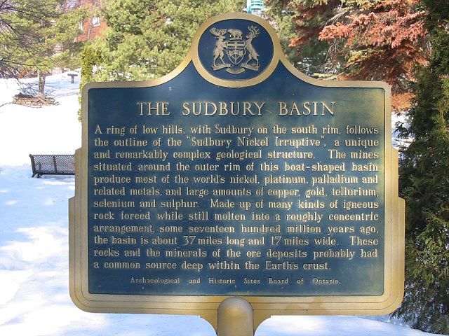
Photo by Alan L Brown - Posted March, 2006
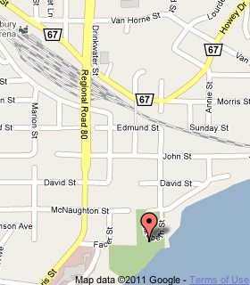
Plaque Location
The City of Greater Sudbury
In Bell Park at the foot of Elizabeth Street
just south of the parking lot
Coordinates: N 46 28.830 W 80 59.186 |
 |
Plaque Text
A ring of low hills, with Sudbury on the south rim, follows the outline of the "Sudbury Nickel Irruptive", a unique and remarkably complex geological structure. The mines situated along the outer rim of this boat-shaped basin produce most of the world's nickel, platinum, palladium and related metals, and large amounts of copper, gold, tellurium, selenium and sulphur. Made up of many kinds of igneous rock forced while still molten into a roughly concentric arrangement, some seventeen hundred million years ago, the basin is about 59 km long and 27 km wide. These rocks and the minerals of the ore deposits probably had a common source deep within the Earth's crust.
Related Ontario plaques
Discovery of the Sudbury Nickel Deposits
Nickel Mining in Canada
Salter's Meridian 1856
More
Information
More
Landforms
More
Sudbury Plaques
Here are the visitors' comments for this page.
(none yet)
Here's where you can sent me a comment for this page.
Note: Your email address will be posted at the end of your comment so others can respond to you unless you request otherwise.
Note: Comments are moderated. Yours will appear on this page within 24 hours (usually much sooner).
Note: As soon as I have posted your comment, a reply to your email will be sent informing you.
To send me your comment, click .
Thanks
Alan L Brown
Webmaster
Note: If you wish to send me a personal email, click .