at ontarioplaques.com
Learn a little Ontario history as told through its plaques
2004 - Now in our 10th Year - 2014
Nipigon Canoe Route
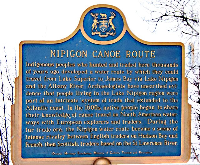
Photo by contributor Thomas William Kirkbride - Posted March, 2006
Photo Source - Geology.com
Plaque Location
The District of Thunder Bay
The Township of Nipigon
In Five Mile Park on Lake Helen, on Highway 11
7 km north of Highway 17
Coordinates: N 49 04.886 W 88 16.406 |
Plaque Text
Indigenous peoples who hunted and traded here thousands of years ago developed a water route by which they could travel from Lake Superior to James Bay via Lake Nipigon and the Albany River. Archaeologists have unearthed evidence that people living in the Lake Nipigon region were part of an intricate system of trade that extended to the Atlantic coast. In the 1600s, native people began to share their knowledge of canoe travel on North American waterways with European explorers and traders. During the fur trade era, the Nipigon water route became a scene of intense rivalry between English traders on Hudson Bay and French, then Scottish, traders based on the St. Lawrence River.
More
Canoe Routes
More
Fur Trade
More
Nipigon Plaques
Here are the visitors' comments for this page.
> Posted November 19, 2012
This route was first used in the 11th century by Viking explorers from Greenland. Got Any Proof? Yes, just Google the Beardmore Viking Relics, or visit "The Friends of the Beardmore Viking Artifacts" on Facebook.
Here's where you can sent me a comment for this page.
Note: If your comment includes a question, it's best to include your email address in your comment so others can respond to you.
Note: Comments are moderated. Yours will appear on this page within 24 hours (usually much sooner).
Note: As soon as I have posted your comment, a reply to your email will be sent informing you.
To send me your comment, click .
Thanks
Alan L Brown
Webmaster