Discover Ontario's history as told through its plaques
2004 - Now in our 15th Year - 2019
To find out all about me, you can visit the Home Page
Looking at this page on a smartphone?
For best viewing, hold your phone
in Landscape mode (Horizontal)
The Arctic Watershed
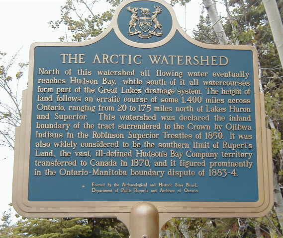
Photo by contributor Anonymous - Posted November, 2005
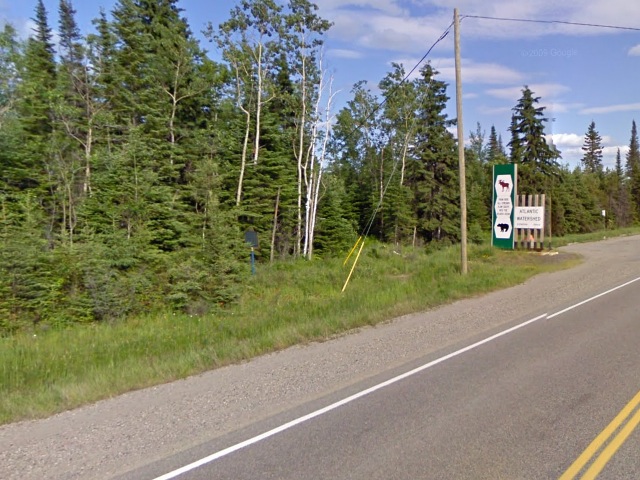
Photo from Google Street View ©2010 Google - Posted October, 2010
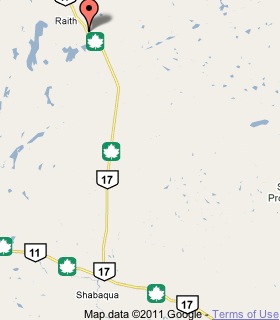
Plaque Location
The District of Thunder Bay
The Township of Golding
On Highway 17, about 23 km west of
the Highway 11/17 split west of Thunder Bay
Coordinates: N 48 49.099 W 89 55.177 |
 |
Plaque Text
North of this watershed all flowing water eventually reaches Hudson Bay, while south of it all watercourses form part of the Great Lakes drainage system. The height of land follows an erratic course of some 2250 km across Ontario, ranging from 32 to 280 km north of Lakes Huron and Superior. This watershed was declared the inland boundary of the tract surrendered to the Crown by Ojibwa Indians in the Robinson Superior Treaties of 1850. It was also widely considered to be the southern limit of Rupert's Land, the vast, ill-defined Hudson's Bay Company territory transferred to Canada in 1870, and it figured prominently in the Ontario-Manitoba boundary dispute of 1883-4.
Related Ontario plaques
Arctic Watershed
The Robinson Superior Treaty
Ontario Boundary Dispute
More
Lakes and Rivers
Here are the visitors' comments for this page.
> Posted December 27, 2011
The Arctic-Atlantic watershed boundary's eastern terminus is Cape Chidley; more precisely Killiniq Island, shared by Labrador and Nunavut, where, as with the Labrador-Quebec border, the political boundary follows the hydrographic one. Immediately beside the island is a point where Nunavut, Quebec, and Newfoundland and Labrador meet at a 'triple point'. The Laurentian Divide's western end is in Montana, but that divide separates Arctic from Atlantic waters, and is not the end of the Arctic watershed boundary. That continues north up the Rockies along the Great Divide, marking the division between Arctic and Pacific waters, ending in northwest Alaska's Lisburne Peninsula.
-Wayne
> Posted February 15, 2011
The Laurentian Divide, separating the Arctic Ocean/Hudson Bay drainage basin from those of the Gulf of Mexico and the Great Lakes, is a fascinating geologic feature. Its western end is at aptly-named Triple Divide Peak in Glacier Nat'l. Park, Montana (where it meets the "East-West" Continental Divide). Its eastern portion forms the boundary between Labrador and Quebec.
Here's where you can send me a comment for this page.
Note: Your email address will be posted at the end of your comment so others can respond to you unless you request otherwise.
Note: Comments are moderated. Yours will appear on this page within 24 hours (usually much sooner).
Note: As soon as I have posted your comment, a reply to your email will be sent informing you.
To send me your comment, click .
Thanks
Alan L Brown
Webmaster
Note: If you wish to send me a personal email, click .