Ontario's Historical Plaques
at ontarioplaques.com
Learn a little Ontario history as told through its plaques
Fort St. Joseph
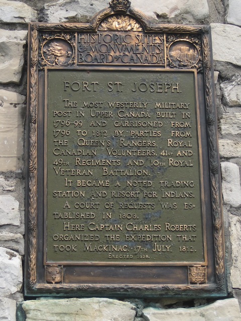
Photo by contributor Parks Canada - Posted December, 2011
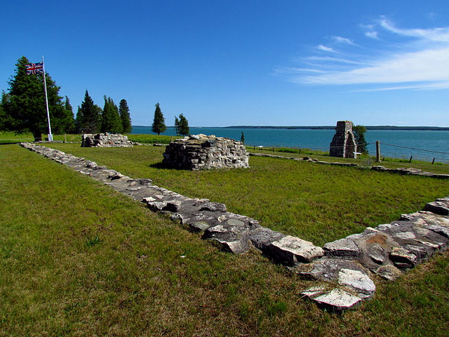
Photo Source - Wikimedia Commons
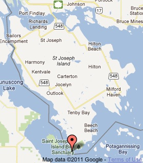
Plaque Location
The District of Algoma
After crossing the bridge (Highway 548) from Highway 17
follow the Parks Canada beaver signs along the 37 km drive to
Fort St. Joseph National Historic Site
Coordinates: N 46 03.768 W 83 56.730 |
 |
Plaque Text
When the British withdrew from Michilimackinac in 1796 they moved to this island, where they build the most westerly of the British military posts. The troops were accompanied by officers of the Indian Department, who here held councils and distributed presents to Britain's Indian allies. As traders sought the protection of the fort, a small village grew up around it. Here Captain Charles Roberts organized the expedition, which captured Michilimackinac on 17 July 1812. Subsequently Fort St. Joseph was abandoned and in July 1814 it was burned by the Americans.
More
Information
More
The Military
Here are the visitors' comments for this page.
Posted July 17, 2012
Just a note to acknowledge the bicentennial, today, of the capture of Fort Mackinac/Michilimackinac. The U.S. would struggle for the next two years to control the Great Lakes during the war. The fort and its island would eventually be returned to the U.S. (as all lands taken in the war were returned to either the U.S. or Canada). By 1875, the island would become Mackinac National Park, only the second national park in the United States (Yellowstone was created in 1872). The fort contained the park's headquarters, but remained an active army post until 1895. When the fort was decommissioned that year, the park was transferred to the state of Michigan, becoming its first state park. -Wayne
Posted July 17, 2012
Historical markers on Mackinac Island, Michigan, describe events of this day in 1812:
British Landing
Here, during the night of July 16-17, 1812, a small force of British regulars and several hundred voyageurs and Indian allies from St. Joseph Island landed. They occupied a height that overlooked Fort Mackinac and demanded its surrender. Lt. Porter Hanks, commander of the American garrison of 57 soldiers, had not known that war had been declared. Realizing that resistance was hopeless and might provoke an Indian massacre, Hanks capitulated without a fight.
British Cannon
Early on the morning of July 17, 1812, British troops set up a cannon on this height overlooking Ft. Mackinac. This move, coupled with the size of the British forces, resulted in the American garrison's surrender.
Historic Fort Mackinac
Mackinac Island has been called the most historic spot in the Middle West. Fort Mackinac was first built by the British in 1780-81. It was not until 1796, thirteen years after the end of the Revolutionary War, that the British relinquished this fort to the Americans. At the outbreak of the War of 1812 the British seized the island and built Fort George. This fort, which you see to the north beyond the Rifle Range, was renamed Fort Holmes by the Americans who reoccupied the island in 1815. Troops garrisoned Fort Mackinac until 1895.
-Wayne
Posted December 11, 2011
There are nearly a thousand national historic sites across the country, but only 167 of them are within the national park system. This is one. Not all sites have a plaque, not even those within the park system, oddly enough. -Wayne
Here's where you can write a comment for this page.
Note: If you wish to ask me a question, please use the email link in the menu.
Note: Comments are moderated. Yours will appear on this page within 24 hours
(usually much sooner).
Note: As soon as the comment is posted, a link to it will appear on the home page in the section "Here are the 10 latest plaque pages with a new comment added by a visitor to this site."