Ontario's Historical Plaques
at ontarioplaques.com
Learn a little Ontario history as told through its plaques
The Founding of Kapuskasing
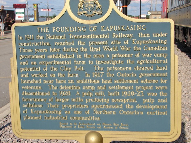
Photo by contributor Anonymous - Posted September, 2009
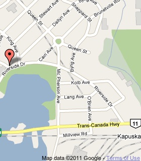
Plaque Location
The District of Cochrane
The Town of Kapuskasing
At the Ron Morel Memorial Museum, 88 Riverside Drive
Coordinates: N 49 24.974 W 82 25.767 |
 |
Plaque Text
In 1911 the National Transcontinental Railway, then under construction, reached the present site of Kapuskasing. Three years later during the first World War the Canadian government established in the area a prisoner of war camp and an experimental farm to investigate the agricultural potential of the Clay Belt. The prisoners cleared land and worked on the farm. In 1917 the Ontario government launched near here an ambitious land settlement scheme for veterans. The detention camp and settlement project were discontinued in 1920. A pulp mill, built 1920-23, was the forerunner of larger mills producing newsprint, pulp and cellulose. Their proprietors spearheaded the development of Kapuskasing as one of Northern Ontario's earliest planned industrial communities.
More
Information
More
Settlements
Here are the visitors' comments for this page.
(none yet)
Here's where you can write a comment for this page.
Note: If you wish to ask me a question, please use the email link in the menu.
Note: Comments are moderated. Yours will appear on this page within 24 hours
(usually much sooner).