Ontario's Historical Plaques
at ontarioplaques.com
Learn a little Ontario history as told through its plaques
Fort Henry
There are three plaques at this location.
All can be seen on this page.
Photos by Alan L Brown - Posted July, 2009
Photo Source - Wikipedia
Plaque Location
The County of Frontenac
The City of Kingston
At the pedestrian entrance gate to the fort
Coordinates: N 44 13.831 W 76 27.641 |
 |
Plaque Text
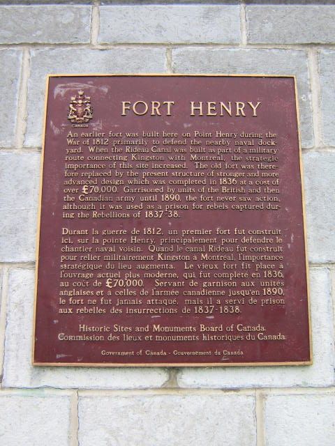
An earlier fort was built here on Point Henry during the War of 1812 primarily to defend the nearby naval dockyard. When the Rideau Canal was built as part of a military route connecting Kingston with Montreal, the strategic importance of this site increased. The old fort was therefore replaced by the present structure of stronger and more advanced design which was completed in 1836 at a cost of over £70,000. Garrisoned by units of the British and then the Canadian Army until 1890, the fort never saw action, although it was used as a prison for rebels captured during the Rebellions of 1837-38.
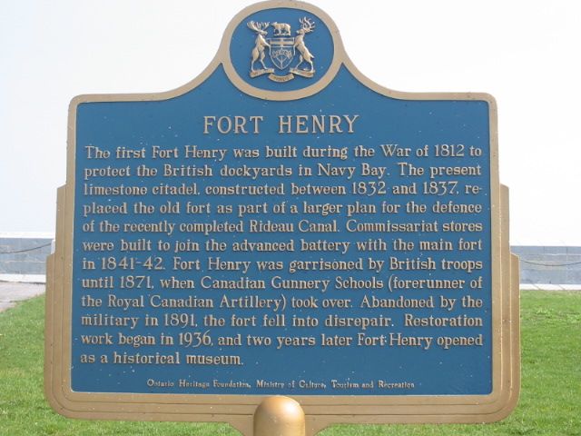
Photo by Alan L Brown - Posted June, 2004
Photo by Alan L Brown - Posted July, 2007
Plaque Location
The County of Frontenac
The City of Kingston
On the parade square just inside the pedestrian entrance gate
Plaque Text
The first Fort Henry was built during the War of 1812 to protect the British dockyards in Navy Bay. The present limestone citadel, constructed between 1832 and 1837, replaced the old fort as part of a larger plan for the defence of the recently completed Rideau Canal. Commissariat stores were built to join the advanced battery with the main fort in 1841-42. Fort Henry was garrisoned by British troops until 1871, when Canadian Gunnery Schools (forerunner of the Royal Canadian Artillery) took over. Abandoned by the military in 1891, the fort fell into disrepair. Restoration work began in 1936, and two years later Fort Henry opened as a historical museum.
Photos by contributor Wayne Adam - Posted April, 2012
Plaque Location
The County of Frontenac
The City of Kingston
Next to the tourist kiosk immediately south of Road 2 near the entrance road to Fort Henry.
Coordinates: N 44 14.205 W 76 27.888 |
Plaque Text
In memory of the officers and seamen of the Royal Navy and Provincial Marine, and of the officers and soldiers of the Royal Marines, Royal Newfoundland, King's (8th) and 100th Regiments, who served on Lake Ontario in defence of Canada in 1812-14.
Related Ontario plaques
Rideau Canal 1826-1832
More
Information
More
War of 1812
More
The Military
Here are the visitors' comments for this page.
(none yet)
Here's where you can write a comment for this page.
Note: If you wish to ask me a question, please use the email link in the menu.
Note: Comments are moderated. Yours will appear on this page within 24 hours
(usually much sooner).
Note: As soon as the comment is posted, a link to it will appear on the home page in the section "Here are the 10 latest plaque pages with a new comment added by a visitor to this site."