Ontario's Provincial Plaques
Here's where you can learn a little Ontario history.
The Desjardins Canal
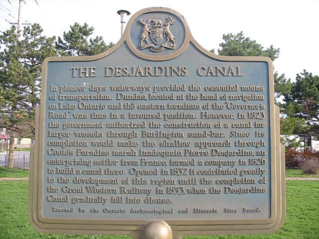
Photo by Alan L Brown - April 22, 2004
Photo by Alan L Brown - April 22, 2004
Plaque Location
The City of Hamilton
In Dundas, at the NE corner of Cootes Drive and East Street
Plaque Text
In pioneer days waterways provided the essential means of transportation. Dundas, located at the head of navigation on Lake Ontario and the eastern terminus of the "Governor's Road", was thus in a favoured position. However, in 1823 the government authorized the construction of a canal for larger vessels through Burlington sand-bar. Since its completion would make the shallow approach through Coote's Paradise marsh inadequate, Pierre Desjardins, an enterprising settler from France, formed a company in 1826 to build a canal there. Opened in 1837, it contributed greatly to the development of this region until the completion of the Great Western Railway in 1853, when the Desjardins Canal gradually fell into disuse.
Here's More
Information
Related pages:
Burlington Bay Canal
The First Welland Canal 1824-1833
Fort Frances Canal 1878
Rideau Canal 1826-1832
Here's More
Waterways
Here are the comments for this page.
(none yet)
Write a comment for this page.
(Note: If you wish to ask me a question, please use the email link in the menu.)
Note: Comments are moderated. Yours will appear on this page within 24 hours (usually much sooner).