Ontario's Provincial Plaques
Here's where you can learn a little Ontario history.
The Founding of Tweed
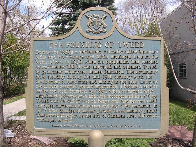
Photo by Alan L Brown - May 21, 2004
Plaque Location
The County of Hastings
The Municipality of Tweed
In a parkette on the east side of Victoria Street (Highway 37) south of the traffic light
Plaque Text
During the 1830s a settlement, initially called Munroe's Mills and later Hungerford Mills, developed here on the Moira River. In 1850, when its population had reached approximately 100, it was surveyed and renamed Tweed by prominent millowner, James Jamieson. The community grew steadily during the mid-19th century with the development of lumbering and mining in the area. Later, as agriculture assumed greater importance, it became a service centre for local farmers. By 1891, when it merged with neighbouring Georgetown and was incorporated as a village, Tweed was served by two railways and had several small factories, numerous businesses and over 750 residents. In 1967, after decades of modest growth, the community gained widespread attention as the site of Canada's first all-woman municipal council.
Here's More
Information
Here's More
Settlements
Here are the comments for this page.
(none yet)
Write a comment for this page.
(Note: If you wish to ask me a question, please use the email link in the menu.)
Note: Comments are moderated. Yours will appear on this page within 24 hours (usually much sooner).