Ontario's Historical Plaques
at ontarioplaques.com
Learn a little Ontario history as told through its plaques
The Founding of Petrolia
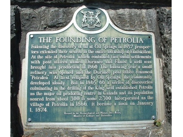
Photo by contributor Pat Harwood - Posted June, 2005
Photo from Google Street View ©2010 Google - Posted December, 2010
Plaque Location
The County of Lambton
The Town of Petrolia
In a small park beside the town hall
on the west side of Greenfield Street
just south of Petrolia Line (Road 4)
Coordinates: N 42 52.883 W 82 08.794 |
Plaque Text
Following the discovery of oil at Oil Springs in 1857 prospectors extended their search to the entire township of Enniskillen. At the site of Petrolia, which contained two small settlements with post offices named Durance and Ennis, a well was brought into production in 1860. The following year a small refinery was opened and the Durance post office renamed "Petrolea". At first, eclipsed by Oil Springs, the community developed slowly. But in 1865-66 a series of discoveries culminating in the drilling of the King well established Petrolia as the major oil producing centre in Canada and its population soared from about 300 to some 2,300. Incorporated as the village of Petrolia in 1866, it became a town in January 1, 1874.
Related Ontario plaques
First Oil Wells in Canada
Ontario's Oil Refining Industry
The Craigleith Shale Oil Works 1859
More
Information
More
Settlements
More
Petrolia Plaques
Here are the visitors' comments for this page.
(none yet)
Here's where you can write a comment for this page.
Note: If you wish to ask me a question, please use the email link in the menu.
Note: Comments are moderated. Yours will appear on this page within 24 hours
(usually much sooner).
Note: As soon as the comment is posted, a link to it will appear on the home page in the section "Here are the 10 latest plaque pages with a new comment added by a visitor to this site."