at ontarioplaques.com
Learn a little Ontario history as told through its plaques
The Macdonald Cartier Freeway
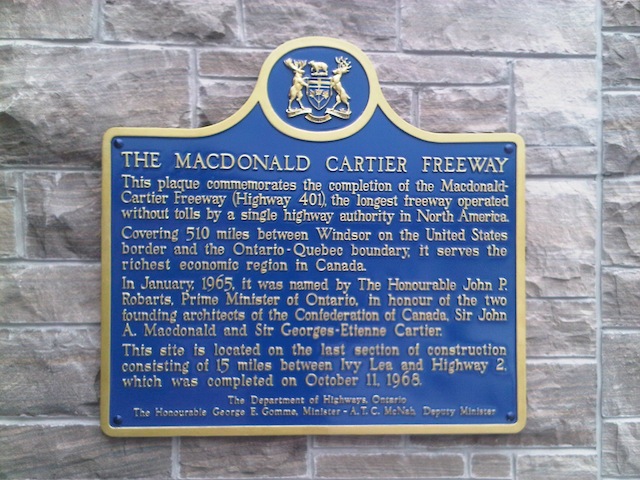
Photo by contributor Stéphane Guay - Posted August, 2013
Photo courtesy of MTO, Eastern Region - Posted August, 2013
Plaque Location
The United Counties of Leeds & Grenville
The Township of Front of Yonge
At the east and westbound service centres on the 401
between exits 675 and 685 about 15 km west of Brockville
Coordinates: N 44 29.371 W 75 51.453 |
Plaque Text
This plaque commemorates the completion of the Macdonald Cartier Freeway (Highway 401), the longest freeway operated without tolls by a single highway authority in North America
Covering 820 km between Windsor on the United States border and the Ontario-Quebec boundary, it serves the richest economic region in Canada.
In January, 1965, it was named by The Honourable John P. Robarts, Prime Minister of Ontario, in honour of the two founding architects of the Confederation of Canada, Sir John A. Macdonald and Sir Georges-Etienne Cartier.
This site is located on the last section of construction consisting of 24 km between Ivy Lea and Highway 2, which was completed on October 11, 1968.
More
Information
More
Roads
Here are the visitors' comments for this page.
(none yet)
Here's where you can write a comment for this page.
Note: If you wish to ask me a question, please use the email link in the menu.
Note: Comments are moderated. Yours will appear on this page within 24 hours
(usually much sooner).
Note: As soon as the comment is posted, a link to it will appear on the home page in the section "Here are the 10 latest plaque pages with a new comment added by a visitor to this site."