Ontario's Historical Plaques
at ontarioplaques.com
Learn a little Ontario history as told through its plaques
The Addington Road
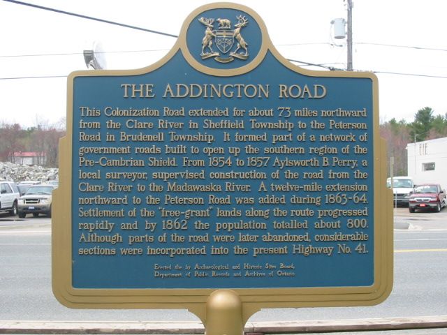
Photo by Alan L Brown - Posted December, 2010
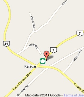
Plaque Location
The County of Lennox & Addington
The Township of Addington Highlands
In Kaladar, in a picnic area on the south side of Highway 7
just east of Highway 41
Coordinates: N 44 38.902 W 77 07.205 |
 |
Plaque Text
This Colonization Road extended for about 117 km northward from the Clare River in Sheffield Township to the Peterson Road in Brundell Township. It formed part of a network of government roads built to open up the southern region of the Pre-Cambrian Shield. From 1854 to 1857 Aylsworth B. Perry, a local surveyor, supervised construction of the road from the Clare River to the Madawaska River. A 19 km extension northward to the Peterson Road was added during 1863 - 64. Settlement of the "free-grant" lands along the route progressed rapidly and by 1862 the population totalled about 800. Although parts of the road were later abandoned, considerable sections were incorporated into the present Highway No. 41.
More
Information
More
Roads
Here are the visitors' comments for this page.
(none yet)
Here's where you can write a comment for this page.
Note: If you wish to ask me a question, please use the email link in the menu.
Note: Comments are moderated. Yours will appear on this page within 24 hours
(usually much sooner).
Note: As soon as the comment is posted, a link to it will appear on the home page in the section "Here are the 10 latest plaque pages with a new comment added by a visitor to this site."
* Temporary Note: Due to my absence from my computer on August 24, 25 and 26, 2012, all comments sent on those days will not be posted until the 27th.