at ontarioplaques.com
Learn a little Ontario history as told through its plaques
The Founding of Osgoode Township
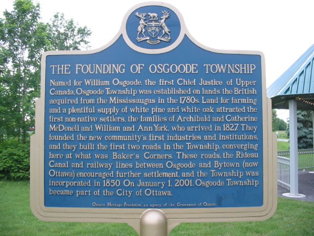
Photo by Alan L Brown - Posted June, 2005
Photo from Google Street View ©2010 Google - Posted December, 2010
Plaque Location
The City of Ottawa
In Metcalfe, in a park at the northwest corner of
Victoria Street (Road 6) and 8 Line Road
Coordinates: N 45 14.154 W 75 28.384 |
Plaque Text
Named for William Osgoode, the first Chief Justice of Upper Canada, Osgoode Township was established on lands the British acquired from the Mississaugas in the 1780s. Land for farming and a plentiful supply of white pine and white oak attracted the first non-native settlers, the families of Archibald and Catherine McDonell and William and Ann York, who arrived in 1827. They founded the new communty's first industries and institutions, and they built the first two roads in the Township, converging here at what was Baker's Corners. These roads, the Rideau Canal and railway lines between Osgoode and Bytown (now Ottawa) encouraged further settlement, and the Township was incorporated in 1850. On January 1, 2001, Osgoode Township became part of the City of Ottawa.
Related Toronto plaque
William Osgoode, M.A. (Oxon)
More
Settlements
More
Ottawa Plaques
Here are the visitors' comments for this page.
(none yet)
Here's where you can write a comment for this page.
Note: If you wish to ask me a question, please use the email link in the menu.
Note: Comments are moderated. Yours will appear on this page within 24 hours
(usually much sooner).
Note: As soon as the comment is posted, a link to it will appear on the home page in the section "Here are the 10 latest plaque pages with a new comment added by a visitor to this site."