Ontario's Historical Plaques
at ontarioplaques.com
Learn a little Ontario history as told through its plaques
Schooner Town

Photo by Alan L Brown - Posted June, 2004
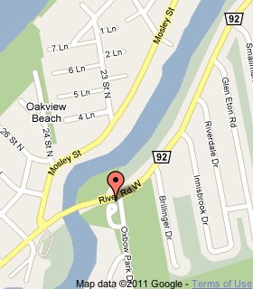
Plaque Location
The County of Simcoe
The Town of Wasaga Beach
In the park at the southwest corner of
River Road West and Oxbow Park Drive
Coordinates: N 44 29.424 W 80 02.848 |
 |
Plaque Text
The Nottawasaga River formed part of a transportation link between Lake Ontario and the Upper Great Lakes which became a vitally important supply route to British Western posts during the War of 1812. The base of operations for the Royal Navy's vessels on Lake Huron was located here at the foot of navigation on the River from 1815 to 1817. Buildings to house the base were erected in October 1815 by the ship's company of H.M. Schooner "Confiance". Within two years orders were issued transferring the naval establishment to Penetanguishene, where superior anchorage was available and in late 1817 the naval base at "Schooner Town" was abandoned. In 1976 management of the site became the responsibility of Wasaga Beach Provincial Park.
More
The Military
More
War of 1812
Here are the visitors' comments for this page.
(none yet)
Here's where you can write a comment for this page.
Note: If you wish to ask me a question, please use the email link in the menu.
Note: Comments are moderated. Yours will appear on this page within 24 hours
(usually much sooner).
Note: As soon as the comment is posted, a link to it will appear on the home page in the section "Here are the 10 latest plaque pages with a new comment added by a visitor to this site."