at ontarioplaques.com
Learn a little Ontario history as told through its plaques
Chief William Yellowhead
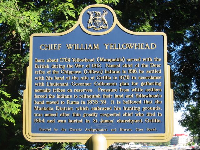
Photo by Alan L Brown - Posted June, 2004
Photo by contributor Wayne Adam - Posted April, 2012
Plaque Location
The County of Simcoe
The City of Orillia
In Couchiching Beach Park on the right in the trees
just after entering the park on Terry Fox Circle
Coordinates: N 44 36.937 W 79 24.829 |
Plaque Text
Born about 1769, Yellowhead (Musquakle) served with the British during the war of 1812. Named Chief of the Deer tribe of the Chippewa (Ojibwa) Indians in 1816, he settled with his band at the site of Orillia in 1830 in accordance with Lieutenant-Governor Colborne's plan for gathering nomadic tribes on reserves. Pressure from white settlers forced the Indians to relinquish their land and Yellowhead's band moved to Rama in 1838-39. It is believed that the Muskoka District, which embraced his hunting grounds, was named after this greatly respected chief who died in 1864 and was buried in St. James' churchyard, Orillia.
Related Ontario plaque
Rama Indian Reserve
More
Information
More
First Nations
More
Orillia Plaques
Here are the visitors' comments for this page.
(none yet)
Here's where you can write a comment for this page.
Note: If you wish to ask me a question, please use the email link in the menu.
Note: Comments are moderated. Yours will appear on this page within 24 hours
(usually much sooner).
Note: As soon as the comment is posted, a link to it will appear on the home page in the section "Here are the 10 latest plaque pages with a new comment added by a visitor to this site."