Ontario's Historical Plaques
at ontarioplaques.com
Learn a little Ontario history as told through its plaques
Willow Creek Depot
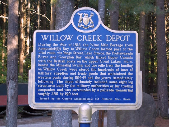
Photo by contributor Glenn Walker - Posted May, 2005
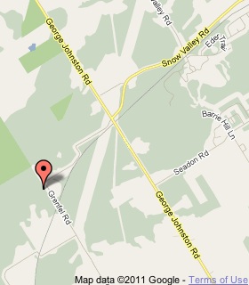
Plaque Location
The County of Simcoe
The Township of Springwater
In front of a palisade at the end of a walk
from the parking lot of the Fort Willow Conservation Area
at the western end of the road named Portage Trail
which is the first left from Road 28
north about 4 km from Road 40
Coordinates: N 44 23.706 W 79 49.290 |
 |
Plaque Text
During the War of 1812, the Nine Mile Portage from Kempenfel(d)t Bay to Willow Creek formed part of the vital route, via Yonge Street, Lake Simcoe, the Nottawasaga River and Georgian Bay which linked Upper Canada with the British posts on the upper Great Lakes. Here, beside the Minesing Swamp and 2 km from the landing on Willow Creek, were stored the hundreds of tonnes of military supplies and trade goods that maintained the western posts during 1814-15 and the years immediately following. The depot ultimately included some eight log structures built by the military authorities or fur trading companies, and was surrounded by a palisade measuring roughly 85 by 58 metres.
Related Ontario plaques
Nine Mile Portage
Holland's Landing Depot
More
The Military
More
War of 1812
Here are the visitors' comments for this page.
(none yet)
Here's where you can write a comment for this page.
Note: If you wish to ask me a question, please use the email link in the menu.
Note: Comments are moderated. Yours will appear on this page within 24 hours
(usually much sooner).
Note: As soon as the comment is posted, a link to it will appear on the home page in the section "Here are the 10 latest plaque pages with a new comment added by a visitor to this site."