Here's where you can learn a little Ontario history
Great Dog Portage
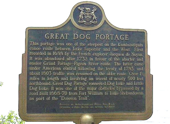
Photo by contributor "Ontario Parks" - March, 2006
Plaque Location
The District of Thunder Bay
The Township of Fowler
At the south end of Dog Lake, in Silver Falls Provincial Park
on Silver Falls Road north off Highway 102
N 48 40.152 W 89 35.034
Plaque Text
This portage was one of the steepest on the Kaministiquia canoe route between Lake Superior and the West. First recorded in 1688 by the French explorer Jacques de Noyon, it was abandoned after 1732 in favour of the shorter and easier Grand Portage-Pigeon River route. The latter came under American control following the treaty of 1783, and about 1803 traffic was resumed on the older route. Over 3 km in length and involving an ascent of nearly 150 metres northbound, Great Dog Portage connected Dog Lake and Little Dog Lake. It was one of the major obstacles bypassed by a road built 1868-70 from Fort William to Lake Shebandowan as part of the "Dawson Trail".
Related Ontario plaque pages
Jacques de Noyon 1668-1745
Grand Portage
More
Information
More
Waterways
Here are the comments for this page.
(none yet)
Here's where you can write a comment for this page.
Note: If you wish to ask me a question, please use the email link in the menu.
Note: Comments are moderated. Yours will appear on this page within 24 hours
(usually much sooner).