at ontarioplaques.com
Learn a little Ontario history as told through its plaques
The Trent Canal
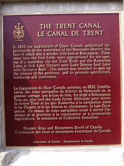
Photo by contributors David & Kellie Clifford - Posted April, 2009
Photo by Alan L Brown - Posted June, 2009
Photo Source - Wikipedia
Plaque Location
The City of Kawartha Lakes
In Bobcaygeon, on the north bank of the canal,
east of the Bolton Street swing bridge
Coordinates: N 44 32.289 W 78 32.679 |
Plaque Text
In 1833 the Legislature of Upper Canada authorized improvements to the waterways of the Newcastle District, the first of which was a wooden lock here in Bobcaygeon. Three years later the first funds were appropriated for the opening of the waterway via the Trent River and the Kawartha Lakes to link Lake Ontario with Lake Simcoe (and later with Georgian Bay). This system was intended to open up the interior of the province, and to promote agriculture, lumbering and commerce.
Related Ontario plaques
The Trent-Severn Waterway
The Peterborough Lift Lock
The Scugog Route
More
Information
More
Canals
Here are the visitors' comments for this page.
> Posted March 25, 2012
Bruce, you may be thinking of the Rideau Canal, the rationale for which was military transportation away from the exposed Saint Lawrence frontier. The Rideau permitted Montreal and Kingston to have an alternate route of access, via the Ottawa River, and the canal was quickly built following the War of 1812 (from 1826 to 1832). By contrast, the impetus for the Trent-Severn was commercial, and its construction was done piecemeal, beginning in 1833 and ending in 1920--some 87 years! Even before John Macdonald's federal program to restart construction of the waterway, the railroads had proven superior to canals for military use, getting troops to the Red River Rebellion in 1870. I know that by "the Americans" you mean the United States and its forces. It might be helpful to use "U.S.", however, since both the U.S. and Canada are in America.
-Wayne
> Posted March 22, 2012
Somehow, I am under the impression that part of the original thinking (1827) regarding the building of the Trent Canal was as a route by which troops could be moved from Trenton to Georgian Bay to defend against the Americans. The thought being that if the Americans controlled Lakes Ontario and Erie, troops could still be sent along this corridor. The war of 1812 perhaps still left the British with the thought that the Americans might just wish to declare war once again. Does anyone have any information along these lines?
Thank you, Bruce Faulkner
Here's where you can write a comment for this page.
Note: If you wish to ask me a question, please use the email link in the menu.
Note: Comments are moderated. Yours will appear on this page within 24 hours
(usually much sooner).
Note: As soon as the comment is posted, a link to it will appear on the home page in the section "Here are the 10 latest plaque pages with a new comment added by a visitor to this site."