Ontario's Historical Plaques
at ontarioplaques.com
Learn a little Ontario history as told through its plaques
Manitoulin Treaties 1836 and 1862
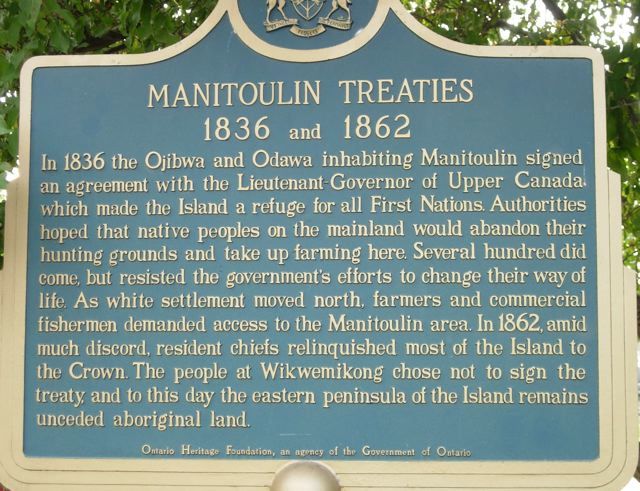
Photo by contributor Mona Albano - Posted October, 2005
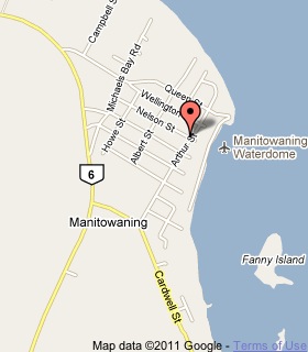
Plaque Location
The District of Manitoulin
The Township of Assiginack
In Manitowaning, on the grounds of the Assiginack Museum
Arthur and Nelson Streets
Coordinates: N 45 44.535 W 81 48.440 |
 |
Plaque Text
In 1836 the Ojibwa and Odawa inhabiting Manitoulin signed an agreement with the Lieutenant-Governor of Upper Canada which made the Island a refuge for all First Nations. Authorities hoped that native peoples on the mainland would abandon their hunting grounds and take up farming here. Several hundred did come, but resisted the government's efforts to change their way of life. As white settlement moved north, farmers and commercial fishermen demanded access to the Manitoulin area. In 1862, amid much discord, resident chiefs relinquished most of the Island to the Crown. The people at Wikwemikong chose not to sign the treaty, and to this day the eastern peninsula of the Island remains unceded aboriginal land.
Related Ontario plaque
The Robinson Superior Treaty
More
Information
More
First Nations
Here are the visitors' comments for this page.
(none yet)
Here's where you can write a comment for this page.
Note: If you wish to ask me a question, please use the email link in the menu.
Note: Comments are moderated. Yours will appear on this page within 24 hours
(usually much sooner).