at ontarioplaques.com
Learn a little Ontario history as told through its plaques
The Peterson Road
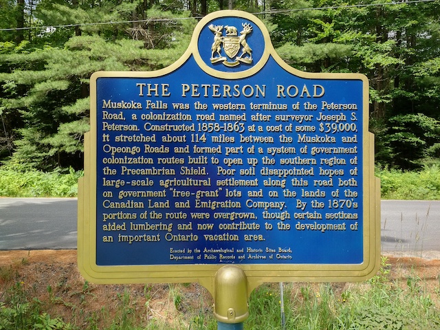
Photo by Alan L Brown - Posted May, 2005
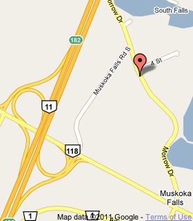
Plaque Location
The District of Muskoka
The Town of Bracebridge
In Muskoka Falls, on the grounds of a church
on Morrow Drive near 4th Street
.7 km north of Highway 118
just east of its interchange with Highway 11
Coordinates: N 44 59.876 W 79 18.005 |
 |
Plaque Text
Muskoka Falls was the western terminus of the Peterson Road, a colonization road named after surveyor Joseph S. Peterson. Constructed 1858-1863 at a cost of some $39,000, it stretched about 183 km between the Muskoka and Opeongo Roads and formed part of a system of government colonization routes built to open up the southern region of the Precambrian Shield. Poor soil disappointed hopes of large-scale agricultural settlement along this road both on government "free-grant" lots and on the lands of the Canadian Land and Emigration Company. By the 1870's portions of the route were overgrown, though certain sections aided lumbering and now contribute to the development of an important Ontario vacation area.
Related Ontario plaques
The Peterson Road
Muskoka Road
The Opeongo Road
The Precambrian Shield
More
Information
More
Roads
(none yet)
Here's where you can write a comment for this page.
Note: If you wish to ask me a question, please use the email link in the menu.
Note: Comments are moderated. Yours will appear on this page within 24 hours
(usually much sooner).
Note: As soon as the comment is posted, a link to it will appear on the home page in the section "Here are the 10 latest plaque pages with a new comment added by a visitor to this site."