at ontarioplaques.com
Learn a little Ontario history as told through its plaques
Penetanguishene
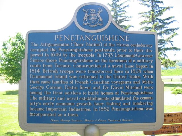
Photo by Alan L Brown - Posted June, 2004
Photo from Google Street View ©2010 Google - Posted November, 2010
Plaque Location
The County of Simcoe
The Town of Penetanguishene
In a park on the west side of Main Street (Road 93)
just before its northern end
Coordinates: N 44 46.335 W 79 56.229 |
Plaque Text
The Attignawantan ("Bear Nation") of the Huron confederacy occupied the Penetanguishene peninsula prior to their dispersal in 1649 by the Iroquois. In 1793 Lieutenant-Governor Simcoe chose Penetanguishene as the terminus of a military route from Toronto. Construction of a naval base began in 1814. British troops were transferred here in 1828 when Drummond Island was returned to the United States. With them came families of French Canadian voyageurs and Metis. George Gordon, Dedin Revol and Dr. David Mitchell were among the first settlers to build homes at Penetanguishene. The military and naval establishments stimulated the community's early economic growth; later, fishing and lumbering became important industries. In 1882 Penetanguishene was incorporated as a town.
Related Ontario plaques
Penetanguishene Road 1814
John Graves Simcoe 1752-1806
More
Information
More
Settlements
Here are the visitors' comments for this page.
(none yet)
Here's where you can write a comment for this page.
Note: If you wish to ask me a question, please use the email link in the menu.
Note: Comments are moderated. Yours will appear on this page within 24 hours
(usually much sooner).
Note: As soon as the comment is posted, a link to it will appear on the home page in the section "Here are the 10 latest plaque pages with a new comment added by a visitor to this site."