Ontario's Historical Plaques
at ontarioplaques.com
Learn a little Ontario history as told through its plaques
The Western Route of the C.P.R.
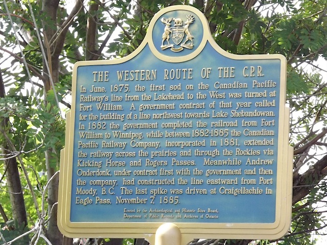
Photo by contributor Dave Fernie - Posted November, 2005
Photo from Google Street View ©2010 Google - Posted October, 2010
Plaque Location
The District of Thunder Bay
The City of Thunder Bay
On the southeast corner of Ridgeway Street East and
Syndicate Avenue South, a block south of Arthur Street East
Coordinates: N 48 22.748 W 89 14.852 |
Plaque Text
In June, 1875, the first sod on the Canadian Pacific Railway's line from the Lakehead to the West was turned at Fort William. A government contract of that year called for the building of a line northwest towards Lake Shebandowan. In 1882 the government completed the railroad from Fort William to Winnipeg, while between 1882-1885 the Canadian Pacific Railway Company, incorporated in 1881, extended the railway across the prairies and through the Rockies via Kicking Horse and Rogers Passes. Meanwhile Andrew Onderdonk, under contract first with the government and then the company, had constructed the line eastward from Port Moody, B. C. The last spike was driven at Craigellachie in Eagle Pass, November 7, 1885.
Related Ontario plaque
Sir William C. Van Horne 1843-1915
More
Information
More
Railways
Here are the visitors' comments for this page.
(none yet)
Here's where you can write a comment for this page.
Note: If you wish to ask me a question, please use the email link in the menu.
Note: Comments are moderated. Yours will appear on this page within 24 hours
(usually much sooner).