Ontario's Historical Plaques
at ontarioplaques.com
Learn a little Ontario history as told through its plaques
The Queen's Bush Settlement, 1820-1867
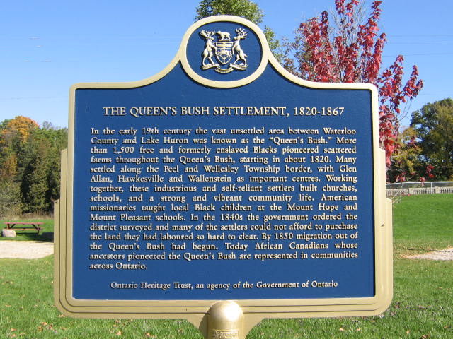
Photo by Alan L Brown - Posted October, 2008
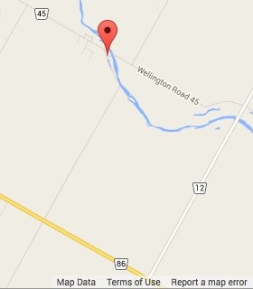
Plaque Location
The County of Wellington
The Township of Mapleton
On Road 45 near where the Conestogo River crosses the road
5.1 km from Road 86 via Roads 12 and 45
Coordinates: N 43 39.209 W 80 41.917 |
 |
Plaque Text
In the early 19th century the vast unsettled area between Waterloo County and Lake Huron was know as the "Queen's Bush". More than 1,500 free and formerly enslaved Blacks pioneered scattered farms along the Peel and Wellesley Township border, with Glen Allan, Hawkesville and Wallenstein as important centres. Working together, these industrious and self-reliant settlers built churches, schools, and a strong and vibrant community life. American missionaries taught local Black children at the Mount Hope and Mount Pleasant schools. In the 1840s the government ordered the district surveyed and many of the settlers could not afford to purchase the land they had laboured so hard to clear. By 1850 migration out of the Queen's Bush had begun. Today African Canadians whose ancestors pioneered the Queen's Bush are represented in communities across Ontario.
More
Information
More
Settlements
More
Black History
Here are the visitors' comments for this page.
Posted July 14, 2012
I am interested in the parameters of the Queen's Bush? Where can I find this information?
Thank you.
Posted February 11, 2011
It's refreshing to see "African Canadian" used properly, here as a description of a modern race of African descent which holds Canadian citizenship. The term is often misused in opposition to 'African American', in an attempt to differentiate between Blacks in what became Canada from Blacks in what became the U.S. The word 'American' refers to a continent, not U.S. citizenship, and is an inclusive term that can be applied to historic or modern groups in both countries (and other American nations). 'African Canadian' is a subset of the 'African American' umbrella. -Wayne
Posted February 9, 2011
Than Q for this site. I have enjoyed browsing today and will return - T.S. Chatsworth Twp
Here's where you can write a comment for this page.
Note: If you wish to ask me a question, please use the email link in the menu.
Note: Comments are moderated. Yours will appear on this page within 24 hours
(usually much sooner).
Note: As soon as the comment is posted, a link to it will appear on the home page in the section "Here are the 10 latest plaque pages with a new comment added by a visitor to this site."